POLSKA. Mapa ziem polskich z zaznaczonymi granicami rozbiorów; A. Blondeau, Hyacinthe Langlois
add您的筆記create
拍品說明
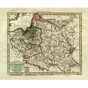
POLSKA. Mapa ziem polskich z zaznaczonymi granicami rozbiorów; ryt. A. Blondeau, pochodzi z:Guthrie, William, Atlas universel pour la géographie, wyd. Hyacinthe Langlois, Paryż 1798; miedz. kolor., st. bdb., lekkie zabrudzenia marginesów; wym. płyty: 238x195 mm; LA POLOGNE AVEC LES PARTAGES de 1772, 1793 et 1795;
![[MAP]. MAP OF POLAND 1 : 500 000. OLSZTYN. [Sheet ] 3. w-wa 1947....](https://img1.one.bid/img/6363/1859794_1x.webp?1713045600)
![Automobile MAP of Poland 1 : 2,000,000 with list of gas stations by 'Karpaty' Nakł. Karpaty Sp. z o.o., Lviv [1933].](https://img1.one.bid/img/6145/1794990_1x.webp?1709593200)
![Automobile MAP of Poland 1 : 2,000,000 with list of gas stations by 'Karpaty' Nakł. Karpaty Sp. z o.o., Lviv [1933].](https://img1.one.bid/img/6145/1794990_2x.webp?1709593200)